By Sudha Ramachandran
BANGALORE (IDN) – As another scorching summer grips India and rivers begin running dry, the government’s Interlinking of Rivers (ILR) program to solve the country’s water problems is being heatedly discussed.
Drawing attention to the water shortage and unequal distribution of water in the country, Prime Minister Narendra Modi, a strong champion of the program, recently pointed out that while some rivers are in spate others are running dry. “If there is inter-linking [of rivers], the problem can be solved,” he said.
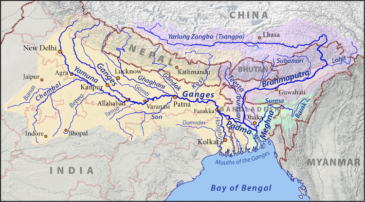
There are stark differences in the per capita availability of water in India’s river basins. According to a 2015 National Water Mission report, the average per capita availability of water in 2010 in the Ganga-Brahmaputra-Meghna system was 20,136 cubic meters compared to just 263 cubic meters in the Sabarmati basin.
Unlike rivers in the north and northeast of the country that are fed by glaciers in the Himalayas, rivers of peninsular India depend on the erratic monsoons. Consequently, while the eastern parts of the Ganga-Brahmaputra-Meghna basin reels under recurrent floods, water is scarce in the river basins in western and southern India. The ILR program is designed to address this inequality of water distribution.
The idea of interlinking rivers is not new; in 1858, a British engineer mooted a plan to interlink India’s rivers to improve inland navigation. Variations of this plan that aimed at addressing the unequal geographic distribution of water were put forward in the 1970s and 1980s but none of these moved beyond the drawing board.
It was only in 2002 when the Bharatiya Janata Party (BJP) came to power in New Delhi that the idea of interlinking rivers began to be considered seriously. It kick-started the program, but the program was put in cold storage for a decade thereafter as the United Progressive Alliance government didn’t support the idea. With the BJP returning to power in 2014, the ILR program has emerged the government’s flagship scheme.
Broadly, the program comprises of two components: the Himalayan rivers component with 14 links and the Peninsula rivers components with 16 links. It will involve construction of around 15,000 km of new canals, and 3,000 big and small dams and storage structures.
On paper it seems rather simple. However, its implementation is complex given the varying terrains and altitudes through which water will have to be channeled. Additionally, the central government will need to get different states to agree on interlinking rivers. People are unlikely to part with their land to make room for the canals and storage structures.
The program is estimated to cost India US$ 87 billion, “a price tag that is worth it,” according to Chetan Pandit, retired Member (Water Planning & Projects), Central Water Commission in India’s Ministry of Water Resources. Since it envisages channeling water away from “surplus” river basins to “deficit” ones, it is likely to improve management of floods and droughts.
Additionally, it is expected to irrigate an additional 35 million hectares of land, boost hydropower generation by around 34,000 megawatts and facilitate inland navigation, according to the Ministry of Water Resources.
However, the ILR program has many critics. Many have challenged the fundamental premise on which it is based i.e. the existence of “surplus” and “deficit” river basins.
According to Shripad Dharmadhikary, founder of Manthan Adhyayan Kendra, an NGO which works on water issues from a sustainable development perspective, the concepts of “surplus” and “deficit” river basins are “completely unscientific and irrational.”
Explaining this to IDN he pointed out that the “quantum and patterns of each river’s natural flows is just what is necessary – neither surplus nor deficit – to maintain and sustain its unique ecosystem.”
“The notions of surplus and deficit used in the ILR context,” Dharmadhikary said, “are indicative of a complete lack of understanding of what ecology and environment mean, and an extreme anthropocentric view of rivers as mere channels carrying water to serve (only) human needs.”
Ashvani Gosain, professor at the Indian Institute of Technology, Delhi, has drawn attention to the impact that climate change can have on the ILR program. Should glacier masses and water volumes in the Himalayan rivers reduce, “surplus” river basins would cease to be “donor basins.”
In addition to the financial costs, ILR will entail “serious” social and environmental costs, warns Dharmadhikary, “as large dams and water diversions would displace hundreds of thousands of people, desiccate rivers downstream, submerge forests and alter the ecology of both, the giving river and the receiving river.”
Water conservationist Rajendra Singh points to the “unique flora and fauna” of a river and warns that these will be destroyed “when the rivers are linked and the waters get mixed.”
Early signs of such destruction are evident in the River Krishna. Following the linking of the Godavari and Krishna rivers in 2015, a growing number of carnivorous fish belonging to the armoured catfish family, which is not native to the Krishna, are appearing in this river. It scares away other fish, even feeding on them. This is impacting the livelihood of local fishermen.
Since ILR is likely to displace people and undermine their livelihoods it will lead to unrest and fuel more conflicts. It can be expected to trigger inter-state conflicts, as well.
A “surplus” state may not want to link its rivers to those in other states. The Odisha government, for instance, is opposed to the Mahanadi-Godavari link as it apprehends a serious shortage of water in the Mahanadi in the coming decades. It is concerned too over the extent of land submergence by the Manibhadra Dam. The Mahanadi-Godavari link being “a mother link” to nine other links, Odisha’s refusal to participate in the ILR could doom the peninsular component of the ILR.
Even more worrying are the implications of diversion of international rivers for India’s neighbors. The proposed diversion of water from the “surplus” Ganga-Brahmaputra-Meghna basin will reduce the water flow to Bangladesh, the lower riparian country.
Already India’s damming of the Ganga and Brahmaputra, especially the construction of the Farakka Barrage just before it enters Bangladesh has caused not only reduce water flow into that country but also, contributed to salinity of the soil, making agriculture almost impossible.
Relations between India and Bangladesh, already strained over the river water issue, can be expected to deteriorate seriously with the ILR program’s implementation.
Proponents of ILR maintain that its challenges notwithstanding, the program must be implemented. “There is no alternative. We have to do it,” says Pandit. Although “there is no such thing as ‘solve our water problems’, every link of the ILR program will reduce the severity of problem in its area,” he adds.
Environmental activist and water expert Himanshu Thakkar says that since “groundwater is India’s lifeline,” its “water policy, programmes and projects need to focus and prioritise how to sustain the groundwater lifeline.”
The ILR will not help achieve that, he points out. According to Thakkar, India should “prioritise optimisation of use of our existing water infrastructure and make “rainwater harvesting the central focus as that can help sustain groundwater.”
India needs to “evolve its agriculture and other livelihood systems, as well as cropping patterns to match the agro-eco-climatic characteristics of each region.” Other economic activities like industries must be located keeping in mind water endowment of the regions, Dharmadhikary says.
Pitted against the powerful infrastructure lobby are an array of scientists, engineers, social scientists, water experts and social activists. Whether the government will heed the concerns raised by experts remains to be seen. [IDN-InDepthNews – 22 April 2018]
Image: Map of the Ganges (orange), Brahmaputra (violet), and Meghna (green) drainage basins. Credit: CC BY-SA 3.0
IDN is the flagship agency of the International Press Syndicate.
Facebook.com/IDN.GoingDeeper – twitter.com/InDepthNews