A Land-Use and Population Capacity Analysis
By Sydney Marcus Silva
NEW JERSEY, USA | 31 December 2025 (IDN) — Sri Lanka’s recurring housing crises, increasingly intensified by climate-related disasters, reflect long-standing structural failures in land-use planning rather than absolute land scarcity. This article examines the relationship between environmental constraints, historical land transformation, and contemporary settlement patterns in Sri Lanka. Drawing on national land-use statistics, conservation data, and population figures, the article estimates the extent of land realistically available for human habitation and evaluates population-carrying capacity under moderate densification scenarios.
The analysis demonstrates that Sri Lanka’s current population can be safely accommodated within existing habitable land without encroaching on protected ecosystems, provided that settlement planning shifts away from environmentally fragile areas toward planned, medium-density development. The findings underscore the need for stricter land governance, reforestation of vulnerable hill-country slopes, and a national housing strategy aligned with environmental limits in the context of accelerating climate risk.
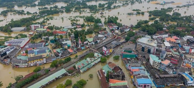
Sri Lanka has experienced persistent housing insecurity since independence, manifested in informal settlements, illegal land occupation, and repeated disaster-related displacement. The impacts of Cyclone Ditwah have once again revealed the vulnerability of housing constructed on unsafe and environmentally inappropriate sites, particularly steep slopes, floodplains, wetlands, and degraded hill-country terrain.
While post-disaster responses often focus on emergency relief and compensation, such measures obscure the deeper structural causes of housing vulnerability. This paper argues that Sri Lanka’s housing crisis is fundamentally a land-use governance problem, shaped by historical environmental transformation, weak regulatory enforcement, and the absence of long-term settlement planning.
This analysis seeks to answer two central questions:
1. How much land in Sri Lanka is realistically available for safe human habitation once environmental and legal constraints are considered?
2. Can Sri Lanka’s current and near-future population be accommodated within this land base under moderate, environmentally sustainable densities?
Historical Context
The roots of Sri Lanka’s contemporary land-use challenges lie in the colonial plantation economy established after 1815. British colonial administration and private mercantile enterprises cleared extensive areas of forest in the central highlands for coffee, cocoa, and later tea cultivation (Department of Forest Conservation; FAO).
This large-scale deforestation disrupted hydrological systems, accelerated soil erosion, and destabilized steep mountain slopes. Numerous studies have documented the long-term consequences of these changes, including:
• Loss of fertile topsoil
• Increased surface runoff and flooding
• High susceptibility to landslides in plantation regions
As a result, significant portions of the hill country have become physically unsuitable for dense human settlement, even though population pressure has increasingly pushed marginalized communities into these areas.
National Land Area and Population
Sri Lanka’s total land area is commonly reported within a range of 62,000–65,600 km², depending on whether inland water bodies are included (Department of Census and Statistics; World Bank). This study adopts this range for analytical robustness.
As of 2025, Sri Lanka’s population is estimated at approximately 23.3 million, with a national average population density of around 370 persons per km² (UN DESA, 2024 revision). However, population distribution is spatially uneven, with high densities in urban and plantation regions and low densities in protected and forested areas.
Protected and Environmentally Restricted Lands
Multiple datasets indicate that a substantial proportion of Sri Lanka’s land area is legally protected or environmentally constrained:
• Forest cover: approximately 34% of land area
• Protected areas: approximately 26.5–30%, including national parks, forest reserves, and sanctuaries
• Environmentally unsuitable lands: wetlands, mangroves, marshes, steep slopes, degraded highlands, and barren lands
These categories overlap partially, but collectively represent land that should not be considered available for new housing development under sustainable planning principles.
Analytical Approach
This study employs a residual land-availability method, widely used in land-use and carrying-capacity assessments. The method begins with total national land area and deducts legally protected and physically unsuitable land categories to estimate a range of potentially habitable land.
Key assumptions
1. All legally protected areas are excluded from housing development.
2. Dense forest cover, whether protected or not, is treated as environmentally unavailable.
3. Wetlands, marshes, mangroves, steep slopes, and degraded highlands are excluded based on historical land-use classifications.
4. Existing built-up areas, agricultural lands, and home-garden systems are considered habitable or potentially habitable.
Estimated Habitable Land Range
• Total land area: ~64,630 km²
• Protected areas (~30%): ~19,400 km²
• Remaining land: ~45,200 km²
• Environmentally unsuitable terrain: ~9,000 km²
Estimated habitable land:** ~36,200–45,000 km²
This range reflects uncertainty in classification but provides a conservative basis for capacity analysis.
Moderate Densification Scenario
This study evaluates population capacity under a moderate density of approximately 600 people per km², characteristic of low-rise suburban and peri-urban development rather than high-density urbanization.
• Low estimate (36,200 km²): ~21.7 million people
• High estimate (45,000 km²): ~27.0 million people
Implications for Current Population
Sri Lanka’s current population of approximately 23.3 million falls within this capacity range. Even under the lower land-availability estimate, only modest increases in density (700–800 people per km² in selected regions) would be required.
Resulting Density on Habitable Land
If the entire population were distributed only across habitable land:
- 36,200 km² → ~643 people per km²
- 45,000 km² → ~518 people per km²
These figures remain well below densities observed in major Asian cities and align with sustainable suburban settlement models.
Discussion
The findings challenge the widely held assumption that Sri Lanka’s housing crisis is driven by land scarcity. Instead, the evidence indicates a misallocation of settlement to environmentally fragile land, exacerbated by weak enforcement of land-use regulations and the absence of coordinated housing policy.
Repeated post-disaster compensation for housing built illegally on unsafe land may provide short-term relief but risks reinforcing unsustainable settlement patterns. Without structural reform, such responses perpetuate cycles of vulnerability and environmental degradation.
A shift toward planned, medium-density settlements—incorporating multi-storey housing, infrastructure, and access to employment—offers a viable alternative to continued encroachment on forests and wildlife habitats.
Policy Implications
The analysis suggests several policy priorities:
1. Strengthening enforcement of land-use and conservation regulations to prevent illegal settlement.
2. Targeted reforestation of high-risk hill-country slopes while safeguarding plantation livelihoods.
3. Development of a national housing and settlement strategy emphasizing semi-rural and suburban growth nodes linked to industry and services.
4. Integration of climate-risk assessment into all housing and land-allocation decisions.
Conclusion
Sri Lanka is not constrained by absolute land scarcity but by the manner in which land has been historically transformed and poorly governed. In an era of intensifying climate change, intelligent land-use planning that respects environmental limits is essential for national resilience. By aligning housing development with ecological realities, Sri Lanka can accommodate its population safely while preserving forests, wildlife, and vital water systems for future generations. [IDN-InDepthNews]
References: Department of Census and Statistics Sri Lanka (2023) Land use statistics of Sri Lanka. Colombo: Government of Sri Lanka.
Department of Census and Statistics Sri Lanka (2024) Population and housing statistics. Colombo: Government of Sri Lanka.
Department of Forest Conservation Sri Lanka (2022) Sri Lanka forest cover assessment. Colombo: Ministry of Wildlife and Forest Conservation.
Food and Agriculture Organization of the United Nations (2022) Global forest resources assessment: Sri Lanka country report. Rome: FAO.
Food and Agriculture Organization of the United Nations (2023) Land, soil and water conservation in South Asia. Bangkok: FAO Regional Office for Asia and the Pacific.
IndexMundi (2024) Sri Lanka land use and environmental indicators. Available at: https://www.indexmundi.com (Accessed: 2025).
United Nations Department of Economic and Social Affairs, Population Division (2024) World population prospects 2024: Medium fertility variant. New York: United Nations.
World Bank (2023) World development indicators: Sri Lanka. Washington, DC: World Bank Group.
WorldAtlas (2024) Geography and land area of Sri Lanka. Available at: https://www.worldatlas.com (Accessed: 2025).